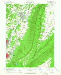
1963 Map of Bellwood
USGS Topo · Published 1965About this map
The Pennsylvania Railroad corridor defines the industrial spine of this Blair County landscape, running parallel to the Little Juniata River through the heart of Bellwood. The mid-century development of the region is evident in the transition from dense rail-side settlements like Reightown and Roots to newer suburban markers such as the Drive-in Theater near Pinecroft. Dominating the central topography is the massive ridge of Brush Mountain, which separates the industrial valley from the agricultural expanses of Sinking Run and the community at Culp. Local history is deeply etched into the hillsides via numerous memorial sites, including the large Rose Hill Cemetery in Altoona East End and the Logan Valley Cemetery. The map also captures critical infrastructure of the era, from the Pottsgrove Reservoir to the State Game Lands No 166.
Find a feature on this map
42 named features on this map. Tap any name to fly to it.
Don’t see what you’re looking for? This feature index may not catch every label — zoom into the map to look around manually.
Map Details
Editions of this 1963 Bellwood Map
4 editions found
Other maps of this area

1901 · Huntingdon
USGS Topo · 1:62,500

1902 · Hollidaysburg
USGS Topo · 1:62,500

1903 · Hollidaysburg
USGS Topo · 1:62,500

1904 · Huntingdon
USGS Topo · 1:62,500

1920 · Altoona
USGS Topo · 1:62,500

1922 · Altoona
USGS Topo · 1:62,500

1923 · Tyrone
USGS Topo · 1:62,500

1929 · Tyrone
USGS Topo · 1:48,000

1933 · Tyrone
USGS Topo · 1:62,500

1946 · Tyrone
USGS Topo · 1:62,500