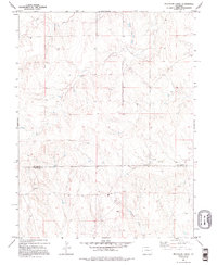
1979 Map of Bellyache Creek
USGS Topo · Published 1995About this map
Kit Carson Co and Cheyenne Co meet along a straight surveyor's line in this high plains landscape of eastern Colorado. The terrain is defined by the intermittent drainage patterns of Sand Creek and the East Branch Bellyache Creek, which carve subtle paths through the sections. This 1970s survey captures a working landscape where water is the primary concern for local inhabitants, marked by isolated infrastructure like a Well and a Tank on the arid range. The presence of Spring Creek and various Springs suggests the vital importance of natural water sources for ranching operations in this sparsely populated region. Detailed fence lines and elevation contours reveal the fine-scale management of the open country before modern development changed the character of the borderlands.
Find a feature on this map
8 named features on this map. Tap any name to fly to it.
Don’t see what you’re looking for? This feature index may not catch every label — zoom into the map to look around manually.
Map Details
Editions of this 1979 Bellyache Creek Map
2 editions found
Other maps of this area

1891 · Arroyo
USGS Topo · 1:125,000

1891 · Kit Carson
USGS Topo · 1:125,000

1893 · Arroyo
USGS Topo · 1:125,000

1893 · Kit Carson
USGS Topo · 1:125,000

1954 · Limon
USGS Topo · 1:250,000

1954 · Lamar
USGS Topo · 1:250,000

1957 · Limon
USGS Topo · 1:250,000

1958 · Limon
USGS Topo · 1:250,000

1958 · Lamar
USGS Topo · 1:250,000

1978 · Sanders Ranch
USGS Topo · 1:24,000