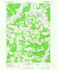
1965 Map of Belmont
USGS Topo · Published 1966About this map
The Genesee River cuts through the heart of this Allegany County landscape, serving as the focal point for the village of Belmont. This mid-1960s survey documents the transition from the river valley to the surrounding uplands, where the Erie-Lackawanna railroad follows the watercourse and Van Campen Creek. The rural economy is clearly visible through clusters of Oil Wells and several gravel pits scattered across the hills. Genealogy researchers will find numerous family and community landmarks, including the Sortore Cem, Maple Grove Cem, and Utopia Cem. The map preserves the layout of small settlements like Belvidere and Higgins during a period of steady industrial and agricultural activity, while the State Reforestation Area in the northwest corner highlights early conservation efforts in the region.
Find a feature on this map
61 named features on this map. Tap any name to fly to it.
Don’t see what you’re looking for? This feature index may not catch every label — zoom into the map to look around manually.
Map Details
Editions of this 1965 Belmont Map
2 editions found
Other maps of this area

1906 · Angelica
USGS Topo · 1:62,500

1916 · Canaseraga
USGS Topo · 1:62,500

1925 · Belmont
USGS Topo · 1:62,500

1926 · Wellsville
USGS Topo · 1:62,500

1939 · Belmont
USGS Topo · 1:62,500

1940 · Canaseraga
USGS Topo · 1:62,500

1941 · Angelica
USGS Topo · 1:62,500

1950 · Elmira
USGS Topo · 1:250,000

1958 · Elmira
USGS Topo · 1:250,000

1960 · Buffalo
USGS Topo · 1:250,000