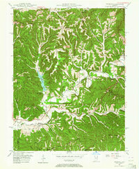
1946 Map of Belmont
USGS Topo · Published 1964About this map
Yellowwood Lake and the dense ridge systems of south-central Indiana define this mid-century landscape. Just after the war, the area shows a clear divide between the expansive Yellowwood State Forest and the beginning of Brown County State Park. The small settlement of Belmont serves as a local hub near State Road 46, supported by the Belmont Sch and nearby Duncan Ch.
Find a feature on this map
85 named features on this map. Tap any name to fly to it.
Don’t see what you’re looking for? This feature index may not catch every label — zoom into the map to look around manually.
Map Details
Editions of this 1946 Belmont Map
2 editions found
Other maps of this area

1942 · Franklin
USGS Topo · 1:125,000

1946 · Belmont
USGS Topo · 1:24,000

1947 · Allens Creek
USGS Topo · 1:24,000

1947 · Unionville
USGS Topo · 1:24,000

1947 · Nashville
USGS Topo · 1:24,000

1947 · Elkinsville
USGS Topo · 1:24,000

1947 · Franklin
USGS Topo · 1:62,500

1948 · Hindustan
USGS Topo · 1:24,000

1948 · Fruitdale
USGS Topo · 1:24,000

1948 · Morgantown
USGS Topo · 1:24,000