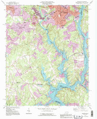
1993 Map of Belmont
USGS Topo · Published 1996About this map
Belmont and Cramerton anchor this 1990s industrial and residential landscape where the South Fork Catawba River meets Lake Wylie. The map reveals a community deeply tied to its educational and industrial roots, featuring the Sacred Heart College and the State Textile Sch alongside localized hubs like Elmores Crossroads. Suburban expansion is evident in the residential grids of South Belmont, yet the presence of older sites like Bethesda Ch and Greenwood Cem preserves the area's genealogical history.
Find a feature on this map
60 named features on this map. Tap any name to fly to it.
Don’t see what you’re looking for? This feature index may not catch every label — zoom into the map to look around manually.
Map Details
Editions of this 1993 Belmont Map
This is the sole edition of this map. No revisions or reprints were ever made.
Other maps of this area

1905 · Charlotte
USGS Topo · 1:48,000

1907 · Charlotte
USGS Topo · 1:62,500

1914 · Gastonia
USGS Topo · 1:48,000

1916 · Gastonia
USGS Topo · 1:62,500

1941 · Charlotte
USGS Topo · 1:125,000

1942 · Charlotte
USGS Topo · 1:125,000

1947 · Clover
USGS Topo · 1:62,500

1948 · Paw Creek
USGS Topo · 1:24,000

1948 · Charlotte West
USGS Topo · 1:24,000

1949 · Clover
USGS Topo · 1:62,500