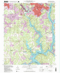
1997 Map of Belmont
USGS Topo · Published 1999About this map
The South Fork Catawba River winds through this 1990s landscape, serving as a corridor for industrial development and settlement between Belmont and Gastonia. The area is marked by a mix of educational institutions and religious sites, ranging from the Sacred Heart College and State Textile Sch to numerous rural sanctuaries like Bethesda Ch and Loves Chapel. This era shows the expansion of South Belmont and the growing residential footprint near the northern reaches of Lake Wylie.
Find a feature on this map
45 named features on this map. Tap any name to fly to it.
Don’t see what you’re looking for? This feature index may not catch every label — zoom into the map to look around manually.
Map Details
Editions of this 1997 Belmont Map
This is the sole edition of this map. No revisions or reprints were ever made.
Other maps of this area

1905 · Charlotte
USGS Topo · 1:48,000

1907 · Charlotte
USGS Topo · 1:62,500

1914 · Gastonia
USGS Topo · 1:48,000

1916 · Gastonia
USGS Topo · 1:62,500

1941 · Charlotte
USGS Topo · 1:125,000

1942 · Charlotte
USGS Topo · 1:125,000

1947 · Clover
USGS Topo · 1:62,500

1948 · Paw Creek
USGS Topo · 1:24,000

1948 · Charlotte West
USGS Topo · 1:24,000

1949 · Clover
USGS Topo · 1:62,500