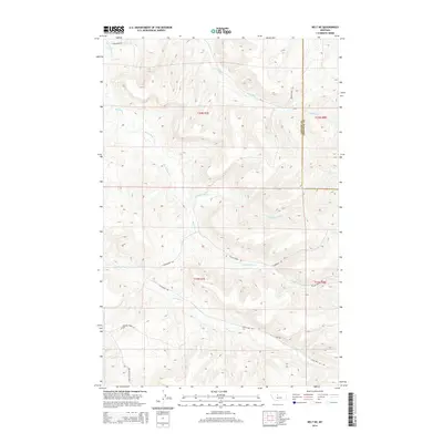
2014 Map of Belt NE
USGS Topo · Published 2014About this map
Big Willow Cr and its numerous tributaries, including N Willow Cr and Middle Willow Cr, define the drainage patterns of this high-plains landscape on the border of Cascade and Chouteau counties. The area is characterized by a network of rural routes that follow the natural contours of the drainages or provide access to remote upland sections. Significant local corridors like Little Belt Rd and the Belt Butte Cut Off suggest a landscape primarily utilized for ranching and large-scale agriculture. The presence of named landmarks such as Burley Hill Rd and Thibedeau Rd points to the long-standing family legacies and homesteading history of this portion of Montana, where the road network often terminates at private landholdings or remote creek crossings like Little Belt Cr.
Find a feature on this map
18 named features on this map. Tap any name to fly to it.
Don’t see what you’re looking for? This feature index may not catch every label — zoom into the map to look around manually.
Map Details
Editions of this 2014 Belt NE Map
This is the sole edition of this map. No revisions or reprints were ever made.
Other maps of this area

1890 · Fort Benton
USGS Topo · 1:250,000

1892 · Fort Benton
USGS Topo · 1:250,000

1897 · Fort Benton
USGS Topo · 1:250,000

1954 · Great Falls
USGS Topo · 1:250,000

1954 · Waltham
USGS Topo · 1:24,000

1956 · Highwood
USGS Topo · 1:62,500

1956 · Belt
USGS Topo · 1:62,500

1957 · Great Falls
USGS Topo · 1:250,000
1975 · Belt SE
USGS Topo · 1:24,000
1975 · Belt NW
USGS Topo · 1:24,000