
1956 Map of Highwood
USGS Topo · Published 1957About this map
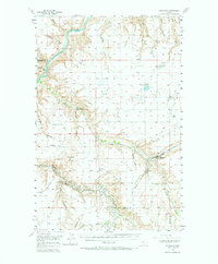
Highwood and the surrounding grain-producing highlands are defined by the winding course of the Missouri River and the industrial infrastructure of the mid-1950s. The Chicago Milwaukee St Paul and Pacific railroad bisects the landscape, serving agricultural stops like Waltham and Lander Crossing. This survey illustrates the intensive water management of the era, visible in the Birkeland Reservoir and Rice Reservoir, alongside significant topographical features such as Shepherd Butte and its namesake Shepherd Butte Sch. The confluence of Belt Creek and numerous deep-cut drainage systems like Widow Coulee and Black Coulee underscores the intricate hydrology of the Chouteau and Cascade county borderlands. The road network, including the Highwood Road, connects rural outposts like Rogers and Four Corners, providing a clear view of the transport and ranching patterns during this period of Montana's development.
Find a feature on this map
33 named features on this map. Tap any name to fly to it.
Don’t see what you’re looking for? This feature index may not catch every label — zoom into the map to look around manually.
Map Details
Editions of this 1956 Highwood Map
2 editions found
Other maps of this area

1886 · Great Falls
USGS Topo · 1:250,000

1890 · Fort Benton
USGS Topo · 1:250,000

1892 · Fort Benton
USGS Topo · 1:250,000

1897 · Fort Benton
USGS Topo · 1:250,000

1948 · Portage
USGS Topo · 1:62,500

1949 · Portage
USGS Topo · 1:62,500

1950 · Dent Bridge
USGS Topo · 1:62,500

1953 · Carter
USGS Topo · 1:24,000

1953 · Tunis
USGS Topo · 1:24,000

1954 · Great Falls
USGS Topo · 1:250,000