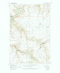
1956 Map of Highwood
USGS Topo · Published 1973About this map
The Missouri River cuts through the northwest corner of this landscape, where the Chicago Milwaukee St Paul and Pacific railroad tracks parallel the water and define the early transportation corridor of the region. The settlement of Highwood serves as a focal point near the center of the map, situated where Highwood Creek and Indian Creek converge. The terrain is marked by a complex network of drainage features known as coulees, including Cherry Coulee, Bird Coulee, and Widow Coulee, which illustrate the erosion patterns of the Missouri River break country.
Find a feature on this map
29 named features on this map. Tap any name to fly to it.
Don’t see what you’re looking for? This feature index may not catch every label — zoom into the map to look around manually.
Map Details
Editions of this 1956 Highwood Map
2 editions found

Other maps of this area

1886 · Great Falls
USGS Topo · 1:250,000

1890 · Fort Benton
USGS Topo · 1:250,000

1892 · Fort Benton
USGS Topo · 1:250,000

1897 · Fort Benton
USGS Topo · 1:250,000

1948 · Portage
USGS Topo · 1:62,500

1949 · Portage
USGS Topo · 1:62,500

1950 · Dent Bridge
USGS Topo · 1:62,500

1953 · Carter
USGS Topo · 1:24,000

1953 · Tunis
USGS Topo · 1:24,000

1954 · Great Falls
USGS Topo · 1:250,000