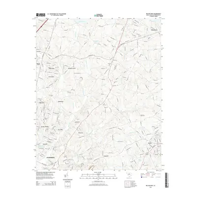
2014 Map of Belton West
USGS Topo · Published 2014About this map
The Rocky River and its numerous tributaries, including Broadway Cr and Cupboard Cr, define the rolling landscape of eastern Anderson County. This 2014 survey documents the residential expansion between the municipal hubs of Anderson and Belton, illustrating a network of subdivisions like Heather Heights, Hampton Acres, and Fox Valley that have grown around established rural corridors. Local heritage is deeply rooted in the scattered community landmarks found throughout the quadrangle, from the Whitefield Church in the north to the Eureka Baptist Cem near the southern edge.
Find a feature on this map
189 named features on this map. Tap any name to fly to it.
Don’t see what you’re looking for? This feature index may not catch every label — zoom into the map to look around manually.
Map Details
Editions of this 2014 Belton West Map
This is the sole edition of this map. No revisions or reprints were ever made.
Other maps of this area

1888 · Pickens
USGS Topo · 1:125,000

1892 · Abbeville
USGS Topo · 1:125,000

1893 · Elberton
USGS Topo · 1:125,000

1894 · Pickens
USGS Topo · 1:125,000

1954 · Greenville
USGS Topo · 1:250,000

1957 · Anderson
USGS Topo · 1:62,500

1957 · Williamston
USGS Topo · 1:62,500

1958 · Greenville
USGS Topo · 1:250,000

1964 · Saylors Crossroads
USGS Topo · 1:24,000
1964 · Anderson South
USGS Topo · 1:24,000