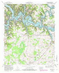
1972 Map of Belvidere
USGS Topo · Published 1982About this map
The Elk River valley is transformed by the impoundment of Tims Ford Lake, which dominates the northern landscape of this survey. The winding reservoir fingers into deep coves like Willie Lake Cove and around prominent landforms including Fanning Bend and Maple Bend. South of the reservoir, the terrain flattens into the agricultural and swampy bottomlands of Mingo Swamp, where a dense network of country roads connects family-named landmarks and rural institutions. The Louisville and Nashville Railroad cuts through this southern section, passing the Kaserman Switch. Researchers will find a high concentration of local genealogy sites, from the Broadview Sch to a constellation of small cemeteries and churches like Burning Bush Ch and Farris Chapel. The eastern edge of the map captures the western growth of Winchester, featuring the National Guard Armory and municipal infrastructure at Kissling Crossing.
Find a feature on this map
90 named features on this map. Tap any name to fly to it.
Don’t see what you’re looking for? This feature index may not catch every label — zoom into the map to look around manually.
Map Details
Editions of this 1972 Belvidere Map
2 editions found
Other maps of this area

1928 · Decherd
USGS Topo · 1:62,500

1936 · Cumberland Springs
USGS Topo · 1:24,000

1936 · Beans Creek
USGS Topo · 1:24,000

1936 · Winchester
USGS Topo · 1:24,000

1936 · Huntland
USGS Topo · 1:24,000

1936 · Belvidere
USGS Topo · 1:24,000

1936 · Pitcher Ridge
USGS Topo · 1:24,000

1936 · Camp Peay
USGS Topo · 1:24,000

1936 · Capitol Hill
USGS Topo · 1:24,000

1936 · Lois
USGS Topo · 1:24,000