
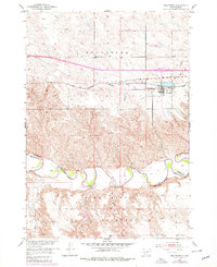
1951 Map of Belvidere
USGS Topo · Published 1952About this map
Belvidere sits as a central hub on this mid-century survey, positioned along the Chicago Milwaukee St Paul and Pacific railroad line. The landscape is defined by the winding course of the White River, which forms a significant geographic and political marker as the White River Reservation Boundary. South of the river lies the northern edge of the Pine Ridge Indian Reservation, where the terrain transitions into a complex network of draws and ridges feeding into Stone Red Creek. Local landmarks like the Willert Sch and Belvidere Cem provide essential anchor points for genealogical research, while the proximity of the rail line to the river illustrates the historical transportation and settlement patterns of Jackson County.
Find a feature on this map
14 named features on this map. Tap any name to fly to it.
Don’t see what you’re looking for? This feature index may not catch every label — zoom into the map to look around manually.
Map Details
Editions of this 1951 Belvidere Map
2 editions found
Other maps of this area

1951 · Pass Creek NW
USGS Topo · 1:24,000

1951 · Stamford SW
USGS Topo · 1:24,000

1951 · Belvidere SW
USGS Topo · 1:24,000

1951 · Cedar Butte NW
USGS Topo · 1:24,000

1951 · Pass Creek NE
USGS Topo · 1:24,000

1953 · Belvidere NE
USGS Topo · 1:24,000

1954 · Belvidere NW
USGS Topo · 1:24,000

1955 · Martin
USGS Topo · 1:250,000

1958 · Martin
USGS Topo · 1:250,000

1972 · Stamford NW
USGS Topo · 1:24,000