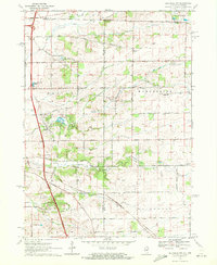
1970 Map of Belvidere NW
USGS Topo · Published 1972About this map
Pinnacle Hill and the rolling terrain of the northern Illinois borderlands dominate this 1970s landscape, where the agricultural traditions of Manchester and Caledonia meet modern transportation corridors. The Northwest Tollway cuts through the western edge of the quadrangle, punctuated by the South Beloit Tollgate. This era shows a transition in local aviation and transit, featuring both the True Airfield near the Wisconsin line and the private Ida-Belle Farm Landing Strip to the south. The rural character is preserved in the network of family-named roads and scattered historic institutions, such as Manchester Ch and several country schools like the Boone School. Numerous cemeteries, including Oak Hill Cem and the Scotch Cem, offer significant points of interest for genealogical research, while the Chicago and North Western tracks illustrate the enduring rail infrastructure of the region.
Find a feature on this map
62 named features on this map. Tap any name to fly to it.
Don’t see what you’re looking for? This feature index may not catch every label — zoom into the map to look around manually.
Map Details
Editions of this 1970 Belvidere NW Map
2 editions found
Other maps of this area

1891 · Janesville
USGS Topo · 1:62,500

1893 · Janesville
USGS Topo · 1:62,500

1893 · Shopiere
USGS Topo · 1:62,500

1918 · Rockford
USGS Topo · 1:62,500

1918 · Belvidere
USGS Topo · 1:62,500

1938 · Rockford
USGS Topo · 1:62,500

1944 · Belvidere
USGS Topo · 1:62,500

1949 · Rockford
USGS Topo · 1:24,000

1954 · Rockford
USGS Topo · 1:250,000

1955 · Rockford
USGS Topo · 1:250,000