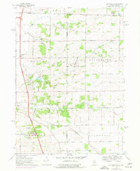
1970 Map of Belvidere NW
USGS Topo · Published 1977About this map
The Wisconsin-Illinois state line bisects this landscape, where the rural townships of Roscoe, Manchester, Harlem, and Caledonia meet across the Winnebago-Boone county boundary. The terrain is defined by the winding paths of Turtle Creek to the north and the split branches of North Kannikinnick Creek and South Kannikinnick Creek further south. This era shows a transition in transportation and land use, with the Northwest Tollway cutting through the western portion of the map while traditional local life remains anchored by sites like Manchester Church and numerous rural schools including White School and Boone School. Multiple gravel pits and quarries are scattered throughout, indicating active local industry. For the family historian, the presence of several established cemeteries such as Pinnacle Hill Cem and Oak Hill Cem provides specific geographic markers for early settlers in these border townships.
Find a feature on this map
58 named features on this map. Tap any name to fly to it.
Don’t see what you’re looking for? This feature index may not catch every label — zoom into the map to look around manually.
Map Details
Editions of this 1970 Belvidere NW Map
2 editions found
Other maps of this area

1891 · Janesville
USGS Topo · 1:62,500

1893 · Janesville
USGS Topo · 1:62,500

1893 · Shopiere
USGS Topo · 1:62,500

1918 · Rockford
USGS Topo · 1:62,500

1918 · Belvidere
USGS Topo · 1:62,500

1938 · Rockford
USGS Topo · 1:62,500

1944 · Belvidere
USGS Topo · 1:62,500

1949 · Rockford
USGS Topo · 1:24,000

1954 · Rockford
USGS Topo · 1:250,000

1955 · Rockford
USGS Topo · 1:250,000