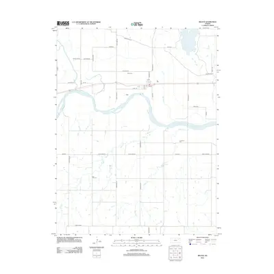
2012 Map of Belvue
USGS Topo · Published 2012About this map
The Kansas River winds through the heart of this landscape, anchoring the settlement of Belvue along the north bank. This 2012 study illustrates the enduring rural structure of Pottawatomie County, where modern transit corridors like Oregon Trail Rd and Old Post Rd trace the historic movement of people through the valley. Local history is deeply embedded in the land, marked by established burial grounds such as Belvue Cem, Greenwood Cem, and Saint Johns Cem. The intricate drainage system is well-defined, showing how tributaries like Vermillion Cr, Wells Cr, and Little Wells Cr feed into the river basin. From the central Po in town to the surrounding grid of family-named thoroughfares like Sublett Rd and Peddicord Rd, the map provides a precise layout of the area's twentieth-century agricultural and residential footprint.
Find a feature on this map
43 named features on this map. Tap any name to fly to it.
Don’t see what you’re looking for? This feature index may not catch every label — zoom into the map to look around manually.
Map Details
Editions of this 2012 Belvue Map
This is the sole edition of this map. No revisions or reprints were ever made.
Other maps of this area

1889 · Wamego
USGS Topo · 1:125,000

1894 · Wamego
USGS Topo · 1:125,000

1953 · Wamego
USGS Topo · 1:24,000

1953 · Maple Hill
USGS Topo · 1:24,000

1953 · Belvue
USGS Topo · 1:24,000

1953 · St Marys
USGS Topo · 1:24,000

1954 · Alma
USGS Topo · 1:24,000

1954 · Mc Farland
USGS Topo · 1:24,000

1955 · Manhattan
USGS Topo · 1:250,000

1956 · Manhattan
USGS Topo · 1:250,000