1954 Map of Alma
USGS Topo · Published 1955About this map
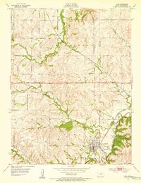
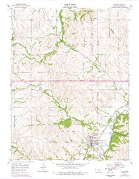
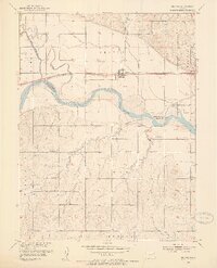
The city of Alma serves as a prominent hub in Wabaunsee County during the mid-1950s, defined by the convergence of two major rail lines. The Atchison Topeka and Santa Fe and the Chicago Rock Island and Pacific railroads intersect near the town center, highlighting the area's importance as a transportation junction. To the north and east, the Potawatomi Reservation Boundary cuts across the landscape, marking a significant historical administrative division.
Find a feature on this map
18 named features on this map. Tap any name to fly to it.
Don’t see what you’re looking for? This feature index may not catch every label — zoom into the map to look around manually.
Map Details
Editions of this 1954 Alma Map
2 editions found
Other maps of this area

1885 · Eskridge
USGS Topo · 1:125,000

1889 · Wamego
USGS Topo · 1:125,000

1889 · Eskridge
USGS Topo · 1:125,000

1894 · Eskridge
USGS Topo · 1:125,000

1894 · Wamego
USGS Topo · 1:125,000
1953 · Wamego
USGS Topo · 1:24,000
1953 · St George
USGS Topo · 1:24,000
1953 · Belvue
USGS Topo · 1:24,000
1953 · Wamego SW
USGS Topo · 1:24,000
1954 · Mc Farland
USGS Topo · 1:24,000