
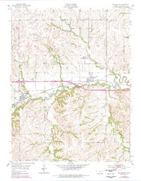
1954 Map of Mc Farland
USGS Topo · Published 1955About this map
McFarland and Paxico anchor this mid-century portrait of Wabaunsee County, where the Chicago Rock Island and Pacific railroad dictates the local geometry of settlement. The tracks parallel the winding course of Mill Creek, a primary drainage that defines the valley floor alongside a protective Levee near Paxico. To the north, the small community of Newbury sits among the headwaters of Mulberry Creek, while the southern half of the quadrangle transitions into more dissected upland terrain. This landscape is marked by numerous family-named watercourses such as Kuenzli Creek and Snokomo Creek, alongside landmarks like Clapboard Canyon. Genealogists will find interest in localized sites like Bethlehem Cem, which serves the rural population living among the ridges and draws south of the rail line.
Find a feature on this map
19 named features on this map. Tap any name to fly to it.
Don’t see what you’re looking for? This feature index may not catch every label — zoom into the map to look around manually.
Map Details
Editions of this 1954 Mc Farland Map
2 editions found
Other maps of this area

1885 · Eskridge
USGS Topo · 1:125,000

1889 · Wamego
USGS Topo · 1:125,000

1889 · Eskridge
USGS Topo · 1:125,000

1894 · Eskridge
USGS Topo · 1:125,000

1894 · Wamego
USGS Topo · 1:125,000

1953 · Wamego
USGS Topo · 1:24,000

1953 · Maple Hill
USGS Topo · 1:24,000

1953 · Belvue
USGS Topo · 1:24,000

1953 · St Marys
USGS Topo · 1:24,000

1954 · Alma
USGS Topo · 1:24,000