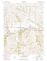
1954 Map of Mc Farland
USGS Topo · Published 1978About this map
McFarland and Paxico serve as the primary rail-oriented hubs in this portion of Wabaunsee County, where the C R I & P railroad follows the winding course of Mill Creek. The landscape is defined by a dense network of drainage systems, including Turkey Creek, Snokomo Creek, and the family-named Kuenzli Creek, all of which cut through the undulating terrain. A distinct local history is visible in the placement of the McFarland Cem and Bethlehem Cem, while the small settlement of Newbury sits north of the rail corridor. Industrial and infrastructure markers, such as the Water Tank and a protective Levee near Paxico, illustrate the constant management of the creek-side environment during the mid-20th century. To the west, the topography deepens into Clapboard Canyon, contrasting with the more developed agricultural and transportation corridor to the east.
Find a feature on this map
21 named features on this map. Tap any name to fly to it.
Don’t see what you’re looking for? This feature index may not catch every label — zoom into the map to look around manually.
Map Details
Editions of this 1954 Mc Farland Map
2 editions found

Other maps of this area

1885 · Eskridge
USGS Topo · 1:125,000

1889 · Wamego
USGS Topo · 1:125,000

1889 · Eskridge
USGS Topo · 1:125,000

1894 · Eskridge
USGS Topo · 1:125,000

1894 · Wamego
USGS Topo · 1:125,000

1953 · Wamego
USGS Topo · 1:24,000

1953 · Maple Hill
USGS Topo · 1:24,000

1953 · Belvue
USGS Topo · 1:24,000

1953 · St Marys
USGS Topo · 1:24,000

1954 · Alma
USGS Topo · 1:24,000