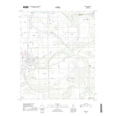
2018 Map of Belzoni
USGS Topo · Published 2018About this map
The Yazoo River dominates this Humphreys County landscape, winding past the city of Belzoni and smaller settlements like Brooklyn and Jaketown. This 2018 survey illustrates a complex system of Oxbow lakes and brakes typical of the Mississippi Delta, including Deadman Lake, Long Lake, and Mathena Brake. For family historians, the sheet is exceptionally well-documented with rural burial sites, including Macedonia Cem, Mount Everet Cem, and Fullilove Cem, often situated near historic plantation tracts and former river bends. The intricate waterway system is further highlighted by features such as Pelican Bend and the Famosla Cut-Off, reflecting the ongoing hydrological management of the Delta's agricultural heartland. Road networks like Deovolente Rd and Silent Shade Rd connect these scattered riverside communities, providing a clear view of the area's modern footprint atop its deep alluvial history.
Find a feature on this map
97 named features on this map. Tap any name to fly to it.
Don’t see what you’re looking for? This feature index may not catch every label — zoom into the map to look around manually.
Map Details
Editions of this 2018 Belzoni Map
This is the sole edition of this map. No revisions or reprints were ever made.
Other maps of this area

1940 · Auter
USGS Topo · 1:62,500

1940 · Baird
USGS Topo · 1:62,500

1940 · Mileston
USGS Topo · 1:62,500

1953 · Greenwood
USGS Topo · 1:250,000

1954 · Mileston
USGS Topo · 1:62,500

1956 · Greenwood
USGS Topo · 1:250,000

1961 · Mossy Lake
USGS Topo · 1:62,500
1965 · Midnight
USGS Topo · 1:24,000

1965 · Inverness
USGS Topo · 1:24,000
1965 · Bellewood
USGS Topo · 1:24,000