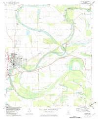
1982 Map of Belzoni
USGS Topo · Published 1983About this map
The Yazoo River defines the geography of this Mississippi Delta landscape, winding south past the city of Belzoni. This early 1980s record captures a highly managed floodplain, where numerous floodgates and levees protect established settlements like Brooklyn and Deovolente from the shifting waters of the river and its many oxbow lakes, including Wasp Lake and Ole Lake. The map reveals a dense network of local landmarks essential for genealogical research, such as Watson Chapel, Mt Everest Ch, and several family-named burial grounds like Carson Cem and Fullilove Cem.
Find a feature on this map
49 named features on this map. Tap any name to fly to it.
Don’t see what you’re looking for? This feature index may not catch every label — zoom into the map to look around manually.
Map Details
Editions of this 1982 Belzoni Map
This is the sole edition of this map. No revisions or reprints were ever made.
Other maps of this area

1940 · Auter
USGS Topo · 1:62,500

1940 · Baird
USGS Topo · 1:62,500

1940 · Mileston
USGS Topo · 1:62,500

1953 · Greenwood
USGS Topo · 1:250,000

1954 · Mileston
USGS Topo · 1:62,500

1956 · Greenwood
USGS Topo · 1:250,000

1961 · Mossy Lake
USGS Topo · 1:62,500
1965 · Midnight
USGS Topo · 1:24,000

1965 · Inverness
USGS Topo · 1:24,000
1965 · Bellewood
USGS Topo · 1:24,000