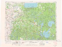
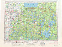
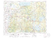
1954 Map of Bemidji
USGS Topo · Published 1966About this map
Lower Red Lake and the vast northern woods of Minnesota dominate this mid-century survey, a landscape defined by water and timber. The central hub of Bemidji sits at the nexus of the Mississippi River and the Great Northern RR, serving as a primary gateway to the surrounding wilderness. To the west, the White Earth Indian Reservation and White Earth Church mark the geography of indigenous lands, while the Red Lake Indian Reservation borders the southern shores of the immense red lakes. This era showcases a transportation network reliant on both steel rails and new highways, with the Soo Line RR and Northern Pacific RR threading through settlements like Fosston, Bagley, and Blackduck. The map reveals the early boundaries of the Chippewa National Forest and several state forests, preserving the headwaters of the Mississippi at Itasca Lake.
Find a feature on this map
64 named features on this map. Tap any name to fly to it.
Don’t see what you’re looking for? This feature index may not catch every label — zoom into the map to look around manually.
Map Details
Editions of this 1954 Bemidji Map
4 editions found

Historical Maps of Bemidji Through Time
3 maps found

