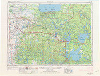
1954 Map of Bemidji
USGS Topo · Published 1974About this map
The city of Bemidji serves as a central hub on this mid-century survey, surrounded by a complex landscape of lakes, forests, and tribal lands. Extensive tracts belonging to the White Earth Indian Reservation, Red Lake Indian Reservation, and Leech Lake Indian Reservation characterize much of the region, while the Chippewa National Forest and Itasca State Park dominate the southeastern and central sectors. The map illustrates a highly developed transportation network of the era, featuring the Great Northern Railway, Northern Pacific Railway, and the Soo Line Railroad connecting settlements like Mahnomen, Fosston, and Walker. This regional snapshot reveals the importance of the timber and recreation economies, marked by numerous lookout towers and fire towers positioned over the dense terrain. Smaller settlements like Redby, Gully, and Gonvick are mapped alongside rural cemeteries and schools, providing valuable data for researchers studying the mid-twentieth-century population distribution of northern Minnesota.
Find a feature on this map
174 named features on this map. Tap any name to fly to it.
Don’t see what you’re looking for? This feature index may not catch every label — zoom into the map to look around manually.
Map Details
Editions of this 1954 Bemidji Map
4 editions found

Other maps of this area

1918 · Terrebonne
USGS Topo · 1:62,500

1918 · Flom
USGS Topo · 1:62,500

1918 · Jelle
USGS Topo · 1:62,500

1918 · Zora
USGS Topo · 1:62,500

1919 · Fosston
USGS Topo · 1:62,500

1919 · Rosy
USGS Topo · 1:62,500

1919 · Grit
USGS Topo · 1:62,500

1919 · Zora
USGS Topo · 1:62,500

1919 · Lundgren
USGS Topo · 1:62,500

1919 · Fox
USGS Topo · 1:62,500