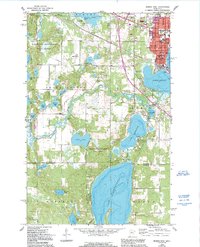
1968 Map of Bemidji West
USGS Topo · Published 1995About this map
The city of Bemidji serves as a northern hub where the Mississippi River connects a chain of significant water bodies including Lake Irving, Lake Marquette, and the expansive Lake Plantagenet. This detailed topographic record, based on 1967 photography with 1990s revisions, illustrates the educational and civic core of the community, featuring Bemidji State College, St Philips Sch, and several local institutions like Riverside Sch and Carr Lake Sch.
Find a feature on this map
52 named features on this map. Tap any name to fly to it.
Don’t see what you’re looking for? This feature index may not catch every label — zoom into the map to look around manually.
Map Details
Editions of this 1968 Bemidji West Map
2 editions found
Other maps of this area

1919 · Solway
USGS Topo · 1:62,500

1920 · Buena Vista
USGS Topo · 1:62,500

1943 · Solway
USGS Topo · 1:62,500

1954 · Bemidji
USGS Topo · 1:250,000

1957 · Bemidji
USGS Topo · 1:250,000

1958 · Bemidji
USGS Topo · 1:250,000

1968 · Guthrie
USGS Topo · 1:24,000

1968 · Bemidji East
USGS Topo · 1:24,000

1968 · Frontenac Lake
USGS Topo · 1:24,000

1968 · Bemidji West
USGS Topo · 1:24,000
Featured Places
- Bemidji, MN
- Wilton, MN
- Skyline Village Mobile Home Park, Bemidji
- Birchlane & Country Lane Mhc, MN
- Westwood Acres, Bemidji