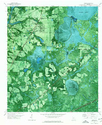
1971 Map of Bemiss
USGS Topo · Published 1976About this map
Moody Air Force Base dominates the northern landscape of this Lowndes County survey, its runways and towers positioned adjacent to the expansive wetlands of Banks Lake. The orthophotomap imagery reveals a transition from military infrastructure and suburban trailer parks to the dense, water-logged reaches of Grand Bay. The Seaboard Coast Line railroad cuts diagonally across the terrain, linking the settlement of Bemiss with smaller locales like Delmar. A strong network of rural community life is evident in the many scattered houses of worship, including New Bethel Ch, Antioch Ch, and Good Hope Ch. Genealogists will find particular value in the documentation of the Hightower Cem and Antioch Cem, situated among the fields and pine stands that characterize this South Georgia region.
Find a feature on this map
31 named features on this map. Tap any name to fly to it.
Don’t see what you’re looking for? This feature index may not catch every label — zoom into the map to look around manually.
Map Details
Editions of this 1971 Bemiss Map
This is the sole edition of this map. No revisions or reprints were ever made.
Other maps of this area

1953 · Waycross
USGS Topo · 1:250,000

1954 · Valdosta
USGS Topo · 1:250,000

1958 · Valdosta
USGS Topo · 1:250,000

1958 · Waycross
USGS Topo · 1:250,000

1959 · Valdosta
USGS Topo · 1:250,000

1961 · Hahira East
USGS Topo · 1:24,000

1961 · Valdosta
USGS Topo · 1:24,000

1968 · Naylor
USGS Topo · 1:24,000

1968 · Lakeland
USGS Topo · 1:24,000

1971 · Indianola
USGS Topo · 1:24,000