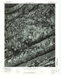
1976 Map of Ben Hur
USGS Topo · Published 1981About this map
Jonesville and Ben Hur anchor this 1976 orthophotomap of southwestern Virginia, where the landscape is defined by the tight, meandering loops of the Powell River. Unlike traditional line maps, this aerial imagery reveals the literal grain of the land, showing the patchwork of forest and clearings along Wallen Creek and the southern slopes toward Blackwater Creek. The settlement pattern follows the contours of the limestone-rich valleys, with roads threading through natural mountain breaks like Tip Top Gap and Hunter Gap. Smaller watercourses such as Town Branch and Sugar Run trace the finer details of the drainage basins, while the photographic detail preserves the exact footprint of farms and homesteads as they existed during the mid-1970s.
Find a feature on this map
13 named features on this map. Tap any name to fly to it.
Don’t see what you’re looking for? This feature index may not catch every label — zoom into the map to look around manually.
Map Details
Editions of this 1976 Ben Hur Map
This is the sole edition of this map. No revisions or reprints were ever made.
Other maps of this area

1887 · Jonesville
USGS Topo · 1:125,000

1891 · Jonesville
USGS Topo · 1:125,000

1894 · Estillville
USGS Topo · 1:125,000

1916 · Nolansburg
USGS Topo · 1:48,000

1919 · Nolansburg
USGS Topo · 1:62,500

1921 · Big Stone Gap
USGS Topo · 1:48,000

1922 · Big Stone Gap
USGS Topo · 1:62,500

1929 · Big Stone Gap
USGS Topo · 1:62,500

1935 · Kyles Ford
USGS Topo · 1:24,000

1935 · Looneys Gap
USGS Topo · 1:24,000