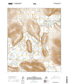
2017 Map of Bendeleben A-6 NW
USGS Topo · Published 2017About this map
The Kuzitrin River winds through the heart of this Seward Peninsula landscape, creating a complex network of wetlands and oxbows within the Nome Census Area. This 2017 survey captures the modern infrastructure of the Kougarok Road/Nome-Taylor Highway as it traverses the eastern edge of the quadrangle, serving as a vital corridor through the subarctic terrain. Significant topographic landmarks rise above the river valley, including the prominent Birch Hill and the distinctively named Hen and Chickens Mtn to the south. Tributaries such as Ptarmigan Cr, Little Ptarmigan Creek, and Hooligan Cr drain the surrounding highlands, illustrating the hydrological patterns of the region. The map provides a clear look at the township and range system, specifically the intersection of T3S and T4S with R30W and R31W, anchoring these natural features within the legal surveying grid of interior Alaska.
Find a feature on this map
13 named features on this map. Tap any name to fly to it.
Don’t see what you’re looking for? This feature index may not catch every label — zoom into the map to look around manually.
Map Details
Editions of this 2017 Bendeleben A-6 NW Map
This is the sole edition of this map. No revisions or reprints were ever made.
Other maps of this area

1950 · Bendeleben A-6
USGS Topo · 1:63,360

1950 · Bendeleben B-6
USGS Topo · 1:63,360

1950 · Teller
USGS Topo · 1:250,000

1950 · Bendeleben
USGS Topo · 1:250,000

1950 · Teller A-1
USGS Topo · 1:63,360

1950 · Teller B-1
USGS Topo · 1:63,360

1951 · Bendeleben
USGS Topo · 1:250,000

1951 · Teller
USGS Topo · 1:250,000

1957 · Teller
USGS Topo · 1:250,000

1958 · Teller
USGS Topo · 1:250,000