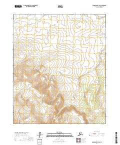
2017 Map of Bendeleben B-1 SW
USGS Topo · Published 2017About this map
Koyuk River winds through the northern reaches of this Seward Peninsula landscape, marking a remote drainage system in the Nome Census Area. The terrain is defined by the headwaters of several significant waterways, including the Tubutulik River in the southwest and the eastern flow of Timber Cr. This 2017 U.S. Geological Survey representation captures the wilderness character of the region before any major modern infrastructure, focusing instead on the natural topography and the intricate network of tributaries like Nutmoyuk Cr. The map provides essential detail for navigating the public land survey system divisions, including portions of T1S R18W and surrounding townships, which are critical for understanding land boundaries in this unpopulated expanse of Alaska.
Find a feature on this map
10 named features on this map. Tap any name to fly to it.
Don’t see what you’re looking for? This feature index may not catch every label — zoom into the map to look around manually.
Map Details
Editions of this 2017 Bendeleben B-1 SW Map
This is the sole edition of this map. No revisions or reprints were ever made.
Other maps of this area

1950 · Bendeleben B-2
USGS Topo · 1:63,360

1950 · Bendeleben B-1
USGS Topo · 1:63,360

1950 · Bendeleben A-2
USGS Topo · 1:63,360

1950 · Bendeleben A-1
USGS Topo · 1:63,360

1950 · Bendeleben
USGS Topo · 1:250,000

1951 · Bendeleben
USGS Topo · 1:250,000

1964 · Bendeleben
USGS Topo · 1:250,000
2017 · Bendeleben A-1 NW
USGS Topo · 1:25,000
2017 · Bendeleben A-1 NE
USGS Topo · 1:25,000
2017 · Bendeleben A-2 NE
USGS Topo · 1:25,000