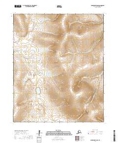
2017 Map of Bendeleben B-6 SW
USGS Topo · Published 2017About this map
Kougarok Road (Nome-Taylor Highway) serves as the primary artery through this interior section of the Seward Peninsula, cutting across the southeastern corner of the landscape. The terrain is defined by a dense network of drainages that feed the region's watersheds, including Ptarmigan Cr and Little Ptarmigan Cr in the south, while Coffee Cr and Dahl Cr carve through the central and northern slopes. This 2017 survey by the U.S. Geological Survey illustrates the relationship between the remote road infrastructure and the natural hydrological system, where numerous small waterways like Atlas Cr and Quartz Cr intersect the upland topography of the Nome Census Area.
Find a feature on this map
16 named features on this map. Tap any name to fly to it.
Don’t see what you’re looking for? This feature index may not catch every label — zoom into the map to look around manually.
Map Details
Editions of this 2017 Bendeleben B-6 SW Map
This is the sole edition of this map. No revisions or reprints were ever made.
Other maps of this area

1950 · Bendeleben A-6
USGS Topo · 1:63,360

1950 · Bendeleben B-6
USGS Topo · 1:63,360

1950 · Teller
USGS Topo · 1:250,000

1950 · Bendeleben
USGS Topo · 1:250,000

1950 · Teller A-1
USGS Topo · 1:63,360

1950 · Teller B-1
USGS Topo · 1:63,360

1951 · Bendeleben
USGS Topo · 1:250,000

1951 · Teller
USGS Topo · 1:250,000

1957 · Teller
USGS Topo · 1:250,000

1958 · Teller
USGS Topo · 1:250,000