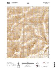
2017 Map of Bendeleben D-3 NW
USGS Topo · Published 2017About this map
The Bering Land Bridge National Preserve encompasses the northwestern portion of this terrain on the Seward Peninsula, preserving a landscape of immense geological and archaeological importance. Centered on the high ground near Mt Foster, the drainage patterns here are defined by numerous seasonal and perennial streams including Hannum Cr, Mystery Cr, and Cunningham Cr. The presence of the Upper Hannum Creek Airport at the base of these ridges highlights the reliance on aerial access in this remote environment where roads are absent. This 2017 survey details the complex network of creeks like Reindeer Cr and Milroy Cr that carve through the northern reaches of the peninsula, providing a clear view of the natural topography before any significant modern development.
Find a feature on this map
16 named features on this map. Tap any name to fly to it.
Don’t see what you’re looking for? This feature index may not catch every label — zoom into the map to look around manually.
Map Details
Editions of this 2017 Bendeleben D-3 NW Map
This is the sole edition of this map. No revisions or reprints were ever made.
Other maps of this area

1950 · Bendeleben
USGS Topo · 1:250,000

1950 · Bendeleben D-3
USGS Topo · 1:63,360

1950 · Bendeleben D-4
USGS Topo · 1:63,360

1950 · Kotzebue A-4
USGS Topo · 1:63,360

1950 · Kotzebue A-3
USGS Topo · 1:63,360

1951 · Bendeleben
USGS Topo · 1:250,000

1951 · Kotzebue
USGS Topo · 1:250,000

1958 · Kotzebue
USGS Topo · 1:250,000

1964 · Bendeleben
USGS Topo · 1:250,000

1964 · Kotzebue
USGS Topo · 1:250,000