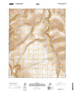
2017 Map of Bendeleben D-3 SE
USGS Topo · Published 2017About this map
The Bering Land Bridge National Preserve occupies the southern portion of this map, representing a protected landscape on the Seward Peninsula where the ancient migration route between continents once stood. The terrain is defined by a dense network of drainage systems, with the Pinnell River and the Inmachuk River cutting through the highlands. Named gold-era watercourses like Eureka Gulch, Snow Gulch, and Old Glory Cr highlight the regional legacy of prospecting and resource extraction. At the western edge, the distinct elevation of Black Butte serves as a prominent landmark above the surrounding creek beds and ridges. This 2017 survey details the hydrology of the area, including American Cr and June Cr, as they flow through the remote townships of the Northwest Arctic Borough.
Find a feature on this map
20 named features on this map. Tap any name to fly to it.
Don’t see what you’re looking for? This feature index may not catch every label — zoom into the map to look around manually.
Map Details
Editions of this 2017 Bendeleben D-3 SE Map
This is the sole edition of this map. No revisions or reprints were ever made.
Other maps of this area

1950 · Bendeleben C-3
USGS Topo · 1:63,360

1950 · Bendeleben C-2
USGS Topo · 1:63,360

1950 · Bendeleben D-2
USGS Topo · 1:63,360

1950 · Bendeleben
USGS Topo · 1:250,000

1950 · Bendeleben D-3
USGS Topo · 1:63,360

1951 · Bendeleben
USGS Topo · 1:250,000

1964 · Bendeleben
USGS Topo · 1:250,000
2017 · Bendeleben D-2 NW
USGS Topo · 1:25,000
2017 · Bendeleben C-2 NW
USGS Topo · 1:25,000
2017 · Bendeleben D-2 SW
USGS Topo · 1:25,000