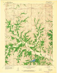
1959 Map of Bendena
USGS Topo · Published 1960About this map
The Chicago Rock Island and Pacific railroad forms a straight horizontal corridor through the northern landscape of Doniphan and Atchison counties, anchoring the settlement at Bendena. This late-1950s survey reveals a rural society organized around its townships, including Wolf River, Center, and Independence. The terrain is deeply carved by drainage systems like Jordan Creek and Independence Creek, which dictate the placement of local landmarks.
Find a feature on this map
24 named features on this map. Tap any name to fly to it.
Don’t see what you’re looking for? This feature index may not catch every label — zoom into the map to look around manually.
Map Details
Editions of this 1959 Bendena Map
2 editions found
Other maps of this area

1885 · Atchison
USGS Topo · 1:125,000

1888 · Atchison
USGS Topo · 1:125,000

1893 · Atchison
USGS Topo · 1:125,000

1926 · Atchison
USGS Topo · 1:62,500

1926 · Oregon
USGS Topo · 1:62,500

1950 · Kansas City
USGS Topo · 1:250,000
1951 · Rushville
USGS Topo · 1:24,000

1954 · Kansas City
USGS Topo · 1:250,000

1956 · Kansas City
USGS Topo · 1:250,000
1959 · Sparks
USGS Topo · 1:24,000