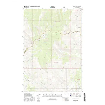
2017 Map of Bender Point
USGS Topo · Published 2017About this map
The Continental Divide serves as the literal and figurative centerpiece of this high-altitude landscape, marking the boundary between Bitterroot National Forest and Beaverhead National Forest. This section of the Anaconda Range is characterized by its dramatic drainage basins, where snowmelt feeds alpine features like Carmine Lake, Surprise Lake, and Violet Lake. The intersection of Ravalli and Beaverhead counties is physically defined by the rugged crest of the divide, with water flowing west into Swift Creek and east toward Mussigbrod Creek. To the south, Bender Point overlooks the lower reaches of Bender Creek, while Buck Ridge Meadows provides a distinct break in the heavy timber of the northern slopes. The presence of the Natl Forest Develop Road 1203 Rd and various forest service routes highlights the ongoing role of the U.S. Forest Service in managing this transition zone between major Montana wilderness areas.
Find a feature on this map
32 named features on this map. Tap any name to fly to it.
Don’t see what you’re looking for? This feature index may not catch every label — zoom into the map to look around manually.
Map Details
Editions of this 2017 Bender Point Map
This is the sole edition of this map. No revisions or reprints were ever made.
Other maps of this area

1955 · Dillon
USGS Topo · 1:250,000

1957 · Dillon
USGS Topo · 1:250,000

1958 · Dillon
USGS Topo · 1:250,000

1962 · Dillon
USGS Topo · 1:250,000

1965 · Dillon
USGS Topo · 1:250,000

1966 · Gibbons School
USGS Topo · 1:24,000

1966 · Big Hole Battlefield
USGS Topo · 1:24,000
1966 · Elk Creek
USGS Topo · 1:24,000
1974 · Bender Point
USGS Topo · 1:24,000
1974 · Lick Creek
USGS Topo · 1:24,000