
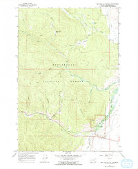
1966 Map of Big Hole Battlefield
USGS Topo · Published 1970About this map
Big Hole National Battlefield occupies the southeastern corner of this mid-1960s study, preserving the site of the 1877 conflict within the Beaverhead National Forest. This high-altitude landscape is defined by the steep slopes of Battle Mountain and the winding course of the North Fork Big Hole River. Local history and archaeology are represented by specific markers such as the Howitzer Pit, while the region's industrial past is visible through evidence of resource extraction. Dredge Tailings along the South Fork and a Prospect on the western flank of the mountain point to the area's mining heritage. A complex network of Pack Trails, Foot Trails, and Jeep Trails crisscrosses the high basins, including Beaver Pond Basin and Maybee Meadows, reflecting the movement of rangers, hunters, and historians through this protected Montana wilderness.
Find a feature on this map
30 named features on this map. Tap any name to fly to it.
Don’t see what you’re looking for? This feature index may not catch every label — zoom into the map to look around manually.
Map Details
Editions of this 1966 Big Hole Battlefield Map
2 editions found
Other maps of this area

1955 · Dillon
USGS Topo · 1:250,000

1957 · Dillon
USGS Topo · 1:250,000

1958 · Dillon
USGS Topo · 1:250,000

1962 · Dillon
USGS Topo · 1:250,000

1965 · Dillon
USGS Topo · 1:250,000

1966 · Gibbons School
USGS Topo · 1:24,000

1966 · Big Hole Pass
USGS Topo · 1:24,000
1966 · Elk Creek
USGS Topo · 1:24,000
1966 · Highland Ranch
USGS Topo · 1:24,000
1966 · Isaac Meadows
USGS Topo · 1:24,000