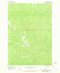
1966 Map of Elk Creek
USGS Topo · Published 1970About this map
Beaverhead National Forest covers this high-altitude landscape in southwest Montana, defined by a dense network of drainages and seasonal watercourses. The 1966 field survey documents a wilderness environment where human presence is largely limited to travel corridors and basic recreation. Joseph Creek and May Creek serve as the primary hydrologic arteries, carving deep through the terrain alongside Stevenson Canyon. Access to these remote reaches is indicated by several Pack Trails and Jeep Trails, showing the traditional routes used by forest rangers, hunters, and early outdoor enthusiasts. The established May Creek Campground provides a specific point of reference for researchers tracing the development of Forest Service recreation facilities in the post-war era. This topographical study captures the area's natural state before more modern forest management practices or expanded recreational infrastructure altered the primitive character of the Elk Creek and Tie Creek basins.
Find a feature on this map
22 named features on this map. Tap any name to fly to it.
Don’t see what you’re looking for? This feature index may not catch every label — zoom into the map to look around manually.
Map Details
Editions of this 1966 Elk Creek Map
2 editions found
Other maps of this area

1955 · Dillon
USGS Topo · 1:250,000

1957 · Dillon
USGS Topo · 1:250,000

1958 · Dillon
USGS Topo · 1:250,000

1962 · Dillon
USGS Topo · 1:250,000

1965 · Dillon
USGS Topo · 1:250,000

1966 · Lost Trail Pass
USGS Topo · 1:24,000

1966 · Big Hole Battlefield
USGS Topo · 1:24,000

1966 · Big Hole Pass
USGS Topo · 1:24,000
1966 · Isaac Meadows
USGS Topo · 1:24,000
1966 · Gibbonsville
USGS Topo · 1:24,000