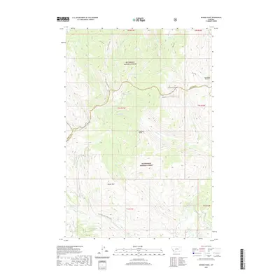
2020 Map of Bender Point
USGS Topo · Published 2020About this map
The Continental Divide serves as a primary geographic marker for this high-country landscape, following the ridgeline that separates Bitterroot National Forest from Beaverhead National Forest. This division is traced by the Continental Divide National Scenic Trail, which traverses the southern edge of the Anaconda Range. The terrain is defined by dramatic elevations, including McCart-Johnson Peak and Bender Point, with numerous alpine water bodies such as Surprise Lake, Phlox Lake, and Violet Lake situated in the upper basins. The map illustrates the headwaters of various drainages, including Hell Roaring Cr and Swift Cr, along with the open spaces of Buck Ridge Meadows. Infrastructure is limited to the Natl Forest Develop Road 1203 Rd and primitive paths, reflecting the region's protected status.
Find a feature on this map
34 named features on this map. Tap any name to fly to it.
Don’t see what you’re looking for? This feature index may not catch every label — zoom into the map to look around manually.
Map Details
Editions of this 2020 Bender Point Map
This is the sole edition of this map. No revisions or reprints were ever made.
Other maps of this area

1955 · Dillon
USGS Topo · 1:250,000

1957 · Dillon
USGS Topo · 1:250,000

1958 · Dillon
USGS Topo · 1:250,000

1962 · Dillon
USGS Topo · 1:250,000

1965 · Dillon
USGS Topo · 1:250,000

1966 · Gibbons School
USGS Topo · 1:24,000

1966 · Big Hole Battlefield
USGS Topo · 1:24,000
1966 · Elk Creek
USGS Topo · 1:24,000
1974 · Bender Point
USGS Topo · 1:24,000
1974 · Lick Creek
USGS Topo · 1:24,000