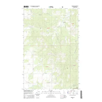
2017 Map of Benewah
USGS Topo · Published 2017About this map
The timbered slopes and creek drainage systems of northern Idaho define this 2017 survey, where the St. Joe National Forest encompasses the high ground of the southeastern quadrant. The small settlement of Benewah is situated along Benewah Creek Rd in the north, serving as a focal point for a network of forest and access roads that wind through the complex topography. Significant elevations include Moses Mtn, which towers over the southern portion of the map, and two prominent gaps in the ridgelines: Windfall Pass and Lolo Pass.
Find a feature on this map
42 named features on this map. Tap any name to fly to it.
Don’t see what you’re looking for? This feature index may not catch every label — zoom into the map to look around manually.
Map Details
Editions of this 2017 Benewah Map
This is the sole edition of this map. No revisions or reprints were ever made.
Other maps of this area

1955 · Spokane
USGS Topo · 1:250,000

1957 · St. Maries
USGS Topo · 1:62,500

1957 · Emida
USGS Topo · 1:62,500

1957 · Plummer
USGS Topo · 1:62,500

1957 · Tensed
USGS Topo · 1:62,500

1958 · Spokane
USGS Topo · 1:250,000

1975 · Plummer SE
USGS Topo · 1:24,000

1981 · St Maries
USGS Topo · 1:100,000
1981 · Benewah Lake
USGS Topo · 1:24,000
1981 · Plummer
USGS Topo · 1:24,000