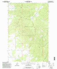
1994 Map of Benewah
USGS Topo · Published 1997About this map
The Coeur D'Alene Indian Reservation dominates this 1990s terrain, where the northern panhandle's geography is defined by a dense network of watercourses and high ridges. The landscape is bisected by the 9th Standard Parallel North, a critical surveying line that cuts across the timbered slopes of Moses Mountain. Water resources are abundant throughout the quadrangle, with drainage provided by systems such as Benewah Creek, Moctileme Creek, and Hangman Creek. Evidence of local industry and infrastructure appears in the form of grain Elevators and a Gravel Pit, pointing to the region's agricultural and resource-based activities. High-elevation travel is marked by landmarks like Windfall Pass and Lolo Pass, while the topography descends toward southern features such as Squaw Hump and the headwaters of Alder Creek.
Find a feature on this map
20 named features on this map. Tap any name to fly to it.
Don’t see what you’re looking for? This feature index may not catch every label — zoom into the map to look around manually.
Map Details
Editions of this 1994 Benewah Map
This is the sole edition of this map. No revisions or reprints were ever made.
Other maps of this area

1955 · Spokane
USGS Topo · 1:250,000

1957 · St. Maries
USGS Topo · 1:62,500

1957 · Emida
USGS Topo · 1:62,500

1957 · Plummer
USGS Topo · 1:62,500

1957 · Tensed
USGS Topo · 1:62,500

1958 · Spokane
USGS Topo · 1:250,000

1975 · Plummer SE
USGS Topo · 1:24,000

1981 · St Maries
USGS Topo · 1:100,000
1981 · Benewah Lake
USGS Topo · 1:24,000
1981 · Plummer
USGS Topo · 1:24,000