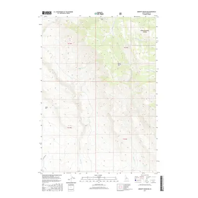
2017 Map of Bennett Mountain
USGS Topo · Published 2017About this map
Bennett Mtn dominates the northern reaches of this Idaho landscape, where the high-altitude terrain marks a transition into the Boise National Forest. The map documents a complex drainage network defining the Mount Bennett Hills, characterized by numerous seasonal and perennial water sources that have long dictated land use in this arid region. The presence of named watering points such as Teapot Spring, High Spring, and Coyote Spring suggests the vital importance of these specific locations for local ranching and transit. Lower elevations are segmented by deep-cut watercourses like Bennett Cr and Ryegrass Cr, while historical access is traced through routes like Ross Rd and SE Hot Creek Rd. To the west, the distinctive bowl of Teapot Basin forms a clear geographic landmark within this section of Elmore County.
Find a feature on this map
20 named features on this map. Tap any name to fly to it.
Don’t see what you’re looking for? This feature index may not catch every label — zoom into the map to look around manually.
Map Details
Editions of this 2017 Bennett Mountain Map
This is the sole edition of this map. No revisions or reprints were ever made.
Other maps of this area

1892 · Mountain Home
USGS Topo · 1:125,000

1892 · Camas Prairie
USGS Topo · 1:125,000

1893 · Mountain Home
USGS Topo · 1:125,000

1893 · Camas Prairie
USGS Topo · 1:125,000

1955 · Hailey
USGS Topo · 1:250,000
1956 · Reverse
USGS Topo · 1:24,000

1956 · Mountain Home
USGS Topo · 1:62,500
1958 · Bennett Mtn
USGS Topo · 1:62,500

1959 · Hailey
USGS Topo · 1:250,000

1960 · Danskin Peak
USGS Topo · 1:62,500