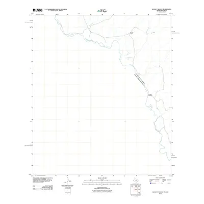
2010 Map of Bennett Ranch
USGS Topo · Published 2010About this map
Rio Grande waters define the international border in this 2010 topographic study, carving a sinuous path between the United States of America and Estados Unidos Mexicanos. The landscape is shaped by the drainage patterns of Sand Creek and the steep walls of Hog Canyon as they descend toward the river valley. Human presence is sparse, centered primarily on the namesake Bennett Ranch in the northern reach of the quadrangle. Historical movement across this borderland is evidenced by Donahue Crossing, a point where the river's geography once facilitated travel between the two nations. This desert terrain is further punctuated by water sources like Ash Spring, which serve as vital landmarks in an otherwise arid expanse of West Texas and Chihuahua.
Find a feature on this map
7 named features on this map. Tap any name to fly to it.
Don’t see what you’re looking for? This feature index may not catch every label — zoom into the map to look around manually.
Map Details
Editions of this 2010 Bennett Ranch Map
This is the sole edition of this map. No revisions or reprints were ever made.
Other maps of this area

1892 · Chispa
USGS Topo · 1:125,000

1895 · Chispa
USGS Topo · 1:125,000

1896 · San Carlos
USGS Topo · 1:125,000

1897 · Eagle Mountain
USGS Topo · 1:125,000

1897 · Chispa
USGS Topo · 1:125,000

1916 · Eagle Mountain
USGS Topo · 1:125,000

1959 · Marfa
USGS Topo · 1:250,000

1965 · Marfa
USGS Topo · 1:250,000
1972 · Bramlett Ranch
USGS Topo · 1:24,000
1972 · Mesquite Spring
USGS Topo · 1:24,000