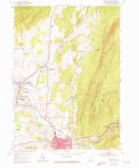
1954 Map of Bennington
USGS Topo · Published 1973About this map
The Battle Monument stands as a focal point in this mid-century portrait of southern Vermont, marking the historic core of Old Bennington near the State Soldiers Home. The landscape is defined by the steep rise of the Green Mountain National Forest to the east, while the valley floor is shaped by the Walloomsac River and the Roaring Branch. This era shows a thriving educational and industrial corridor, featuring the grounds of Bennington College and the established routes of the Rutland Railway and the Ethan Allen Highway. Small rural nodes like Shaftsbury Center and Woodford Hollow remain distinct, populated by numerous local landmarks including the Cobblestone Sch, White Chapel, and the Hinsdellville Cem. The map effectively captures the intersection of early post-war development and the deep-rooted settlement patterns of the Green Mountains.
Find a feature on this map
56 named features on this map. Tap any name to fly to it.
Don’t see what you’re looking for? This feature index may not catch every label — zoom into the map to look around manually.
Map Details
Editions of this 1954 Bennington Map
3 editions found
Other maps of this area

1894 · Equinox
USGS Topo · 1:62,500

1895 · Cambridge
USGS Topo · 1:62,500

1896 · Equinox
USGS Topo · 1:62,500

1897 · Hoosick
USGS Topo · 1:62,500

1898 · Cambridge
USGS Topo · 1:62,500

1898 · Bennington
USGS Topo · 1:62,500

1900 · Taconic
USGS Topo · 1:125,000

1900 · Equinox
USGS Topo · 1:62,500

1901 · Cambridge
USGS Topo · 1:62,500

1903 · Mettawee
USGS Topo · 1:125,000