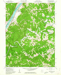
1960 Map of Bens Run
USGS Topo · Published 1962About this map
Ohio River industrial sites and rural West Virginia ridge settlements define this 1960s landscape. Along the riverbank, the Baltimore and Ohio railroad serves the community of Bens Run, where a Salt Evaporator and Salt Wells indicate the area's chemical and mineral processing history. Upriver, Lock and Dam No 16 manages the waterway near Beavertown and the Long Reach substation. Away from the water, the terrain shifts to the winding curves of Middle Island Creek and high ground like Federal Ridge. Genealogists will find a wealth of family-named landmarks and rural burial grounds, including the Oak Grove Cem, Mt Pleasant Cem, and Point Lookout Ch Cem. Small communities like Arvilla, Wasp, and Twiggs are linked by timbered ridges and narrow creek bottoms, while the eastern edge is marked by the remote Falls Mills and Meadville settlements.
Find a feature on this map
61 named features on this map. Tap any name to fly to it.
Don’t see what you’re looking for? This feature index may not catch every label — zoom into the map to look around manually.
Map Details
Editions of this 1960 Bens Run Map
3 editions found
Other maps of this area

1905 · West Union
USGS Topo · 1:62,500

1905 · New Matamoras
USGS Topo · 1:62,500

1906 · Saint Marys
USGS Topo · 1:62,500

1906 · New Martinsville
USGS Topo · 1:62,500

1924 · St Marys
USGS Topo · 1:62,500

1924 · New Martinsville
USGS Topo · 1:62,500

1924 · New Matamoras
USGS Topo · 1:62,500

1924 · West Union
USGS Topo · 1:62,500

1926 · New Martinsville
USGS Topo · 1:62,500

1926 · New Matamoras
USGS Topo · 1:62,500