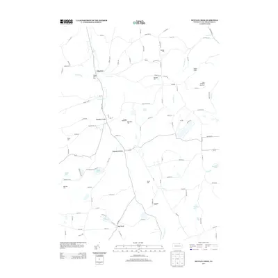
2013 Map of Bentley Creek
USGS Topo · Published 2013About this map
Bentley Creek and the surrounding highlands of northern Bradford County define this landscape, where early transit routes like the Berwick Tpke follow the natural contours of the northern Appalachians. The terrain is characterized by a series of prominent rises such as East Canfield Mountain, Mormon Hill, and Butler Hill, which separate numerous glacial ponds and small drainage basins. High-elevation water bodies like Lake Ondawa and Big Pond serve as local landmarks near the southern edge of the sheet. To the north, the small settlement of Ridgebury sits near the dramatic Three Falls Glen, illustrating the steep ravines carved by tributaries like Threefall Run. The map provides a detailed view of the rural road network connecting scattered agricultural properties and small centers such as Middletown, which remain centered on these vital water sources and mountain passes.
Find a feature on this map
110 named features on this map. Tap any name to fly to it.
Don’t see what you’re looking for? This feature index may not catch every label — zoom into the map to look around manually.
Map Details
Editions of this 2013 Bentley Creek Map
This is the sole edition of this map. No revisions or reprints were ever made.
Other maps of this area

1895 · Elmira
USGS Topo · 1:62,500

1902 · Waverly
USGS Topo · 1:62,500

1905 · Watkins Glen
USGS Topo · 1:125,000

1931 · Troy
USGS Topo · 1:48,000

1938 · Troy
USGS Topo · 1:62,500

1939 · Sayre
USGS Topo · 1:62,500

1942 · Sayre
USGS Topo · 1:62,500

1948 · Sayre
USGS Topo · 1:62,500

1950 · Elmira
USGS Topo · 1:250,000
1953 · Elmira
USGS Topo · 1:24,000
Featured Places
- Springfield Township, PA
- Athens Township, PA
- South Creek Township, PA
- Smithfield Township, PA
- Ridgebury Township, PA