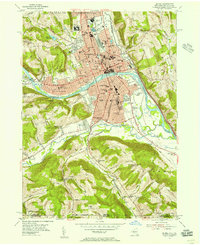
1953 Map of Elmira
USGS Topo · Published 1955About this map
The Chemung River cuts a wide path through the valley, anchoring a landscape where rail lines and urban growth meet the rising hills of the Southern Tier. In the early 1950s, the city is a hub of institutional and industrial life, evidenced by the large complex of the Elmira Reformatory and the sprawling campus of Elmira College. Dense residential blocks are peppered with neighborhood anchors like School No 11 and St Patricks Sch, while the massive Woodlawn Cemetery occupies a significant portion of the northern heights.
Find a feature on this map
77 named features on this map. Tap any name to fly to it.
Don’t see what you’re looking for? This feature index may not catch every label — zoom into the map to look around manually.
Map Details
Editions of this 1953 Elmira Map
2 editions found
Other maps of this area

1895 · Elmira
USGS Topo · 1:62,500

1902 · Waverly
USGS Topo · 1:62,500

1905 · Watkins Glen
USGS Topo · 1:125,000

1931 · Troy
USGS Topo · 1:48,000

1938 · Troy
USGS Topo · 1:62,500

1939 · Sayre
USGS Topo · 1:62,500

1942 · Sayre
USGS Topo · 1:62,500

1948 · Sayre
USGS Topo · 1:62,500

1950 · Elmira
USGS Topo · 1:250,000
1953 · Horseheads
USGS Topo · 1:24,000