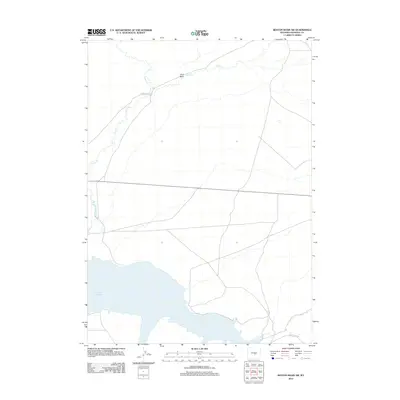
2012 Map of Benton Basin SW
USGS Topo · Published 2012About this map
Pathfinder Reservoir dominates the southern reaches of this Natrona County landscape, reflecting the water management and agricultural shifts of the early 21st century. The map provides a detailed view of the high desert terrain, where seasonal drainages like Pino Draw and Horse Creek carve through the open range. Modern infrastructure is represented by routes such as Oregon Trail Rd, a name that underscores the historical importance of this corridor as a primary path for westward expansion. Further east, Fish Creek winds across the northern plains, while Bishop Point Rd provides access toward the reservoir's rugged shoreline. The sparse distribution of named features highlights the quiet, utilitarian nature of the basin, preserved here during a 2012 survey by the U.S. Geological Survey.
Find a feature on this map
6 named features on this map. Tap any name to fly to it.
Don’t see what you’re looking for? This feature index may not catch every label — zoom into the map to look around manually.
Map Details
Editions of this 2012 Benton Basin SW Map
This is the sole edition of this map. No revisions or reprints were ever made.
Other maps of this area

1951 · Benton Basin SW
USGS Topo · 1:24,000

1951 · Benton Basin
USGS Topo · 1:24,000

1951 · Pathfinder Reservoir NW
USGS Topo · 1:24,000

1951 · Benton Basin NE
USGS Topo · 1:24,000

1951 · Mc Cleary Reservoir
USGS Topo · 1:24,000

1951 · Pathfinder Dam
USGS Topo · 1:24,000

1951 · Fort Ridge
USGS Topo · 1:24,000

1955 · Casper
USGS Topo · 1:250,000

1958 · Casper
USGS Topo · 1:250,000

1959 · Horse Creek Springs
USGS Topo · 1:24,000