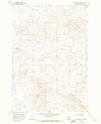
1969 Map of Bentonite Flats
USGS Topo · Published 1972About this map
Bentonite Flats dominates this portion of the Crow Indian Reservation, a landscape defined by the drainage network of Big Woody Creek and its tributary, Little Woody Creek. Surveyed in the late 1960s, the map reveals a sparsely settled region where land use is marked by scattered infrastructure and water management. To the south, Beauvais Creek cuts through the terrain near a landmark simply labeled Custer and a modern Radio Tower. The presence of a Flowing Well and several Drill Hole sites suggests the importance of water access and geological exploration in this part of Big Horn County. This map provides a clear record of the reservation's topography and hydrology before significant modern developments, capturing the character of the Montana plains during this era.
Find a feature on this map
11 named features on this map. Tap any name to fly to it.
Don’t see what you’re looking for? This feature index may not catch every label — zoom into the map to look around manually.
Map Details
Editions of this 1969 Bentonite Flats Map
This is the sole edition of this map. No revisions or reprints were ever made.
Other maps of this area

1893 · Huntley
USGS Topo · 1:125,000

1894 · St. Xavier
USGS Topo · 1:125,000

1894 · Fort Custer
USGS Topo · 1:125,000

1901 · St. Xavier
USGS Topo · 1:125,000

1915 · Spenceville
USGS Topo · 1:31,680

1954 · Billings
USGS Topo · 1:250,000

1954 · Hardin
USGS Topo · 1:250,000

1957 · Hardin
USGS Topo · 1:250,000

1957 · Billings
USGS Topo · 1:250,000

1958 · Billings
USGS Topo · 1:250,000