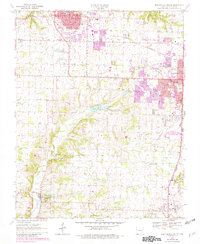
1970 Map of Bentonville South
USGS Topo · Published 1982About this map
Bentonville and Rogers dominate the northern and eastern portions of this map, showing the rapid expansion of these Ozark communities between the late 1960s and 1980. The terrain is defined by the headwaters of Osage Creek, which flows south past a notable Minnow Farm toward Cave Springs. This area of Northwest Arkansas reflects a transition from rural agricultural land to a more dense suburban network, with several small family cemeteries such as Dodson Cem and Hart Cem preserved amidst the shifting landscape.
Find a feature on this map
43 named features on this map. Tap any name to fly to it.
Don’t see what you’re looking for? This feature index may not catch every label — zoom into the map to look around manually.
Map Details
Editions of this 1970 Bentonville South Map
3 editions found
Other maps of this area

1899 · Fayetteville
USGS Topo · 1:125,000

1901 · Fayetteville
USGS Topo · 1:125,000

1904 · Fayetteville
USGS Topo · 1:125,000

1954 · Tulsa
USGS Topo · 1:250,000

1958 · Sonora
USGS Topo · 1:24,000

1958 · Rogers
USGS Topo · 1:24,000

1958 · Pea Ridge
USGS Topo · 1:24,000

1958 · Tulsa
USGS Topo · 1:250,000

1963 · Tulsa
USGS Topo · 1:250,000

1970 · Robinson
USGS Topo · 1:24,000