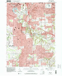
1994 Map of Berea
USGS Topo · Published 2000About this map
The southern suburbs of Cleveland show a complex landscape of residential growth and preserved natural corridors in this mid-1990s survey. The city of Berea serves as a major focal point, anchored by Baldwin-Wallace College and the sprawling County Fairgrounds. The geography is defined by the deep incisions of the Rocky River Metro Res and its tributaries like Baldwin Creek, which create green buffers between the dense street grids of Middleburg Heights and Strongsville.
Find a feature on this map
64 named features on this map. Tap any name to fly to it.
Don’t see what you’re looking for? This feature index may not catch every label — zoom into the map to look around manually.
Map Details
Editions of this 1994 Berea Map
This is the sole edition of this map. No revisions or reprints were ever made.
Other maps of this area

1902 · Berea
USGS Topo · 1:62,500

1903 · Cleveland
USGS Topo · 1:62,500

1903 · Akron
USGS Topo · 1:62,500

1904 · Berea
USGS Topo · 1:62,500

1904 · Medina
USGS Topo · 1:62,500

1905 · Akron
USGS Topo · 1:62,500

1906 · Medina
USGS Topo · 1:62,500

1950 · Cleveland
USGS Topo · 1:250,000

1953 · West View
USGS Topo · 1:24,000

1953 · Broadview Heights
USGS Topo · 1:24,000