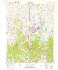
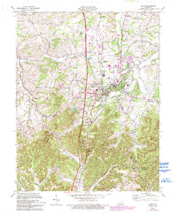
1970 Map of Berea
USGS Topo · Published 1979About this map
Berea College dominates the central landscape of this 1970s revision, illustrating the institutional growth and urban layout of the town at the intersection of KY 21 and U S 25. The map captures the geographic transition from the flatter Peggy Flats in the north to the rising elevation of the Knobs, punctuated by distinctive landmarks like Dead Horse Knob and Bear Mtn. The surrounding countryside is dotted with small rural communities and family-named sites such as Terrill, Farristown, and Middletown, many centered around local congregations like Middletown Ch and Glades Ch. As the Louisville and Nashville railroad and Interstate 75 parallel each other through the center of the sheet, the map reveals how modern transportation corridors began to redefine the traditional settlement patterns along Silver Creek and Brushy Fork.
Find a feature on this map
63 named features on this map. Tap any name to fly to it.
Don’t see what you’re looking for? This feature index may not catch every label — zoom into the map to look around manually.
Map Details
Editions of this 1970 Berea Map
5 editions found
Other maps of this area

1892 · Richmond
USGS Topo · 1:125,000

1893 · London
USGS Topo · 1:125,000

1897 · Richmond
USGS Topo · 1:125,000

1897 · London
USGS Topo · 1:125,000

1952 · Berea
USGS Topo · 1:24,000

1952 · Paint Lick
USGS Topo · 1:24,000

1952 · Kirksville
USGS Topo · 1:24,000

1952 · Bighill
USGS Topo · 1:24,000

1952 · Moberly
USGS Topo · 1:24,000

1953 · Richmond South
USGS Topo · 1:24,000