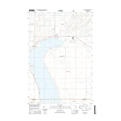
2014 Map of Bergland
USGS Topo · Published 2014About this map
Bergland sits at the northern tip of Lake Gogebic, where the shoreline curves into the sheltered waters of Bergland Bay. This 2014 survey captures the settlement at the junction of State Hwy 28 and State Hwy 64, serving as a gateway to the expansive Ottawa National Forest. The local geography is defined by a dense network of tributaries including Indian Cr, Three Bears Cr, and Trestle Cr, all flowing through the timbered reaches of Deer Wood. Genealogists and local historians can locate established burial sites at Forest Lawn Cem and Lakeview Cem, both situated north of the bay. The map also delineates the county line between Ontonagon and Gogebic counties, tracing how early township divisions like t49n r42w organized the land around the West Branch Ontonagon River and smaller interior bodies of water like Stanko Lake.
Find a feature on this map
33 named features on this map. Tap any name to fly to it.
Don’t see what you’re looking for? This feature index may not catch every label — zoom into the map to look around manually.
Map Details
Editions of this 2014 Bergland Map
This is the sole edition of this map. No revisions or reprints were ever made.
Other maps of this area

1949 · Matchwood NW
USGS Topo · 1:24,000

1949 · Bergland NE
USGS Topo · 1:24,000

1952 · Thayer
USGS Topo · 1:62,500

1955 · Marenisco
USGS Topo · 1:62,500

1955 · Marenisco
USGS Topo · 1:24,000

1956 · Bergland NE
USGS Topo · 1:24,000

1956 · Bergland
USGS Topo · 1:62,500

1956 · Matchwood NW
USGS Topo · 1:24,000

1956 · Matchwood
USGS Topo · 1:62,500

1958 · Iron River
USGS Topo · 1:250,000