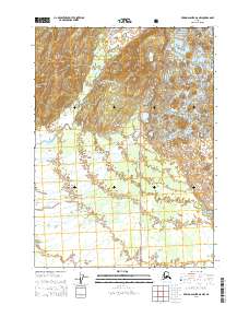
2014 Map of Bering Glacier A-8 NW
USGS Topo · Published 2014About this map
Nichawak Mountain and Mount Campbell dominate this stretch of the Chugach National Forest in southern Alaska, where alpine ice and glacial melt define the drainage patterns of the coastal range. The landscape is primarily shaped by the Waxel Glacier and the complex hydrography of the Chugach Mountains, feeding into the lower reaches of the Edwardes River and the Campbell River. This 2014 survey documents the remote wilderness character of the region, tracing the winding paths of Sewah Cr and the position of Lake Roselius against the high peaks. The map provides a precise look at the township and range boundaries, such as t19s r8e, within this protected federal territory, illustrating the intersection of glaciated highlands and the braided river systems that flow toward the Gulf of Alaska.
Find a feature on this map
13 named features on this map. Tap any name to fly to it.
Don’t see what you’re looking for? This feature index may not catch every label — zoom into the map to look around manually.
Map Details
Editions of this 2014 Bering Glacier A-8 NW Map
This is the sole edition of this map. No revisions or reprints were ever made.
Other maps of this area

1948 · Cordova
USGS Topo · 1:250,000

1950 · Bering Glacier
USGS Topo · 1:250,000

1950 · Cordova A-1
USGS Topo · 1:63,360

1951 · Bering Glacier
USGS Topo · 1:250,000

1951 · Cordova
USGS Topo · 1:250,000

1951 · Cordova B-1
USGS Topo · 1:63,360

1953 · Cordova B-1
USGS Topo · 1:63,360
1953 · Cordova A-1
USGS Topo · 1:63,360

1959 · Bering Glacier
USGS Topo · 1:250,000

1959 · Cordova
USGS Topo · 1:250,000